Utility Mapping
Utility mapping involves the accurate identification, mapping, and management of both underground and above-ground utility networks, which include water supply systems, sewer networks, reclaimed water lines, gas pipelines, electrical infrastructures, and telecommunication assets. Our GIS-based utility mapping solutions enhance asset visibility, reduce maintenance costs, support effective infrastructure planning, and mitigate risks during construction and excavation activities.
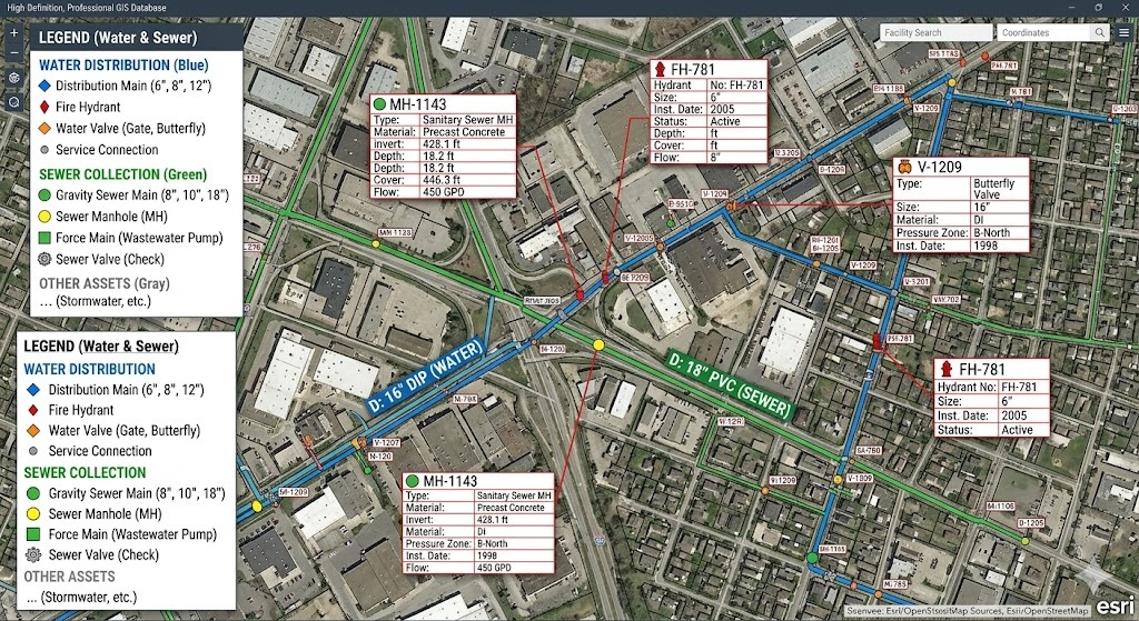
Water Distribution Mapping
We develop comprehensive GIS databases for water distribution networks, encompassing pipelines, valves, hydrants, meters, pumps, and storage facilities. Precise mapping of water utilities enables organizations to monitor assets, optimize maintenance efforts, enhance service reliability, and facilitate future infrastructure expansion.
Sewer Network Mapping
Our sewer mapping solutions provide detailed spatial information on gravity mains, force mains, manholes, lift stations, and wastewater treatment facilities. GIS-based sewer mapping fosters efficient asset management, network analysis, maintenance planning, and compliance with regulatory standards.
Reclaimed Water Mapping
We create GIS datasets for reclaimed water systems, detailing transmission pipelines, distribution networks, storage facilities, and customer connections. Accurate mapping of reclaimed water infrastructure supports sustainable water resource management, enhances operational efficiency, and aids long-term planning initiatives.
Benefits
- Improved asset visibility and inventory management
- Faster maintenance and emergency response
- Reduced excavation and construction risks
- Enhanced infrastructure planning and decision-making
- Advanced utility network analysis and reporting
- Reliable geospatial data for enterprise GIS systems
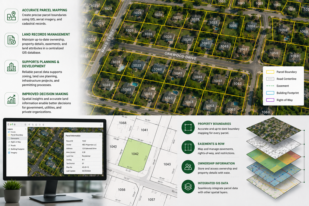
Parcel Mapping provides accurate digital representation of land parcels, property boundaries, easements, rights-of-way, and ownership information using advanced GIS technology. By integrating cadastral records, survey data, and aerial imagery, we create reliable parcel datasets that support land administration, urban planning, infrastructure development, and property management activities.
Our GIS-based parcel mapping solutions help organizations maintain up-to-date land records, improve boundary accuracy, streamline property identification, and support informed decision-making. Detailed parcel information enables efficient management of land assets while ensuring consistency across spatial and administrative databases.
With precise boundary mapping and centralized GIS integration, parcel data can be easily analyzed, updated, and shared across departments. This improves operational efficiency, enhances planning capabilities, and provides a reliable foundation for land management, taxation, utility coordination, and development projects.
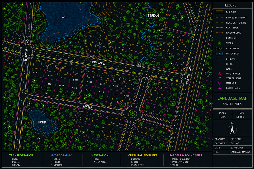
Landbase Management provides the creation and maintenance of accurate GIS base maps containing roads, buildings, parcels, water bodies, vegetation, transportation networks, and other geographic features. These comprehensive landbase datasets serve as the foundation for utility mapping, asset management, planning, engineering, and infrastructure development projects.
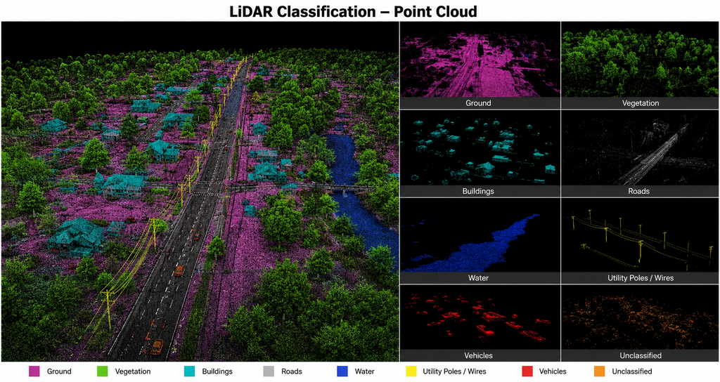
LiDAR Classification involves the processing and classification of LiDAR point cloud data into meaningful categories such as ground, buildings, vegetation, roads, water bodies, and utility structures. Accurate classification improves the quality of spatial analysis and supports the generation of reliable geospatial products.
Our team utilizes industry-standard workflows and advanced tools to deliver high-precision classified datasets for mapping, engineering design, infrastructure planning, environmental studies, and terrain modeling. The resulting data provides a strong foundation for DEM, DTM, contour generation, and other GIS applications.
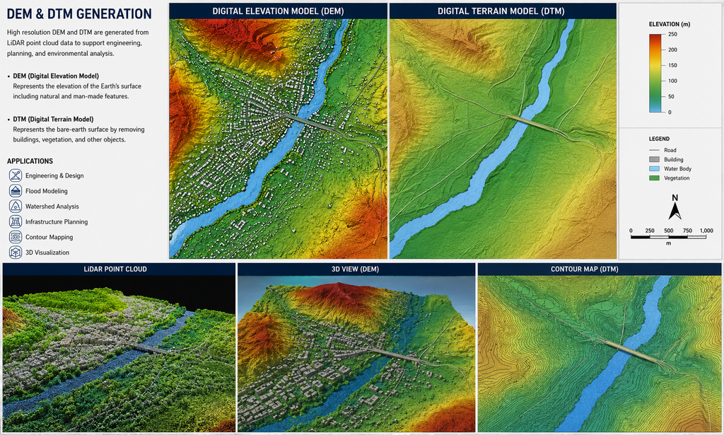
Digital Elevation Models (DEM) and Digital Terrain Models (DTM) are generated from LiDAR point cloud data and other elevation sources to provide accurate representations of the earth's surface. DEMs capture elevation information including natural and man-made features, while DTMs represent the bare-earth terrain by removing buildings, vegetation, and other surface objects.
Our DEM and DTM generation services support engineering design, flood modeling, watershed analysis, infrastructure planning, corridor mapping, and terrain visualization. Using advanced processing techniques, we deliver high-quality elevation datasets that enable accurate analysis, improved decision-making, and reliable project execution.
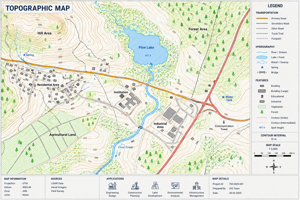
Topographic Mapping provides detailed representation of natural and man-made features, including terrain elevations, contours, roads, buildings, water bodies, vegetation, and infrastructure assets. Using LiDAR, survey, and aerial imagery data, we create accurate topographic maps that support engineering design, construction planning, land development, and environmental analysis.
Our topographic mapping solutions deliver reliable spatial information for project planning, site assessment, corridor studies, and infrastructure management. The resulting maps help organizations make informed decisions by providing a clear understanding of terrain conditions and geographic features.